Site Manager
PRIMRE/Databases/Projects Database/Test Sites/EMEC Billia Croo Wave Test Site
From Open Energy Information
< PRIMRE | Databases | Projects Database | Test Sites
![]()
EMEC Billia Croo Wave Test Site
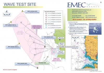
The European Marine Energy Centre (EMEC) Billia Croo grid-connected wave test site was constructed in 2003. It is placed on the western edge of the Orkney mainland, at Billia Croo outside Stromness. Subjected to the powerful forces of the North Atlantic Ocean, it is an area with one of the highest wave energy potentials in Europe with an average significant wave height of 2–3 m, but reaching extremes of up to 18 m (the highest wave recorded by EMEC to date).
The site consists of five cabled (grid-connected) offshore berths in deep water (four in 50 m depth, one in up to 70 m depth) and two nearshore berths in shallow water depths (not grid-connected). The five deep water berths are located approximately 2 km offshore and 0.5 km apart.
The five 11 kV subsea cables feed into the EMEC substation which houses the main switchgear, backup generator and communications room, and has been carefully designed to minimize visual impact. Three waverider buoys are located on site measuring the wave height, period and direction, and a purpose-built weather station provides real-time meteorological data for the site. This data is fed into a sophisticated SCADA (Supervisory, Control and Data Acquisition) system, with live data available to view on EMEC's website. The test site berths are monitored by CCTV from an observation point located at a former coastguard lookout station and controlled remotely.
Additional Information
Device Status
Is the test site actively testing or in planning (active)? Or is it permanently closed for business (inactive)?
Active
Energy Resource
- Wave
Duration
October 2003 -
Ongoing
Max Load Capacity
The maximum amount of electricity that can be accommodated at the test site, based on cable capacity.
7 MW
Grid Connectivity
Grid Connected
Number of Berths
7
Waterbody
Billia Croo, Stromness, United Kingdom
Site Characteristics
Geographic characterization for the test site location:
- Open Ocean: Main body of ocean, not enclosed or partially enclosed by land
- Coastal: Open water near the coast, spanning between land and shelf boundary
- Enclosed Bay: water that is partially surrounded by land, with a mouth open to larger water
- Constricted Channel: A channel where water flows quickly due to narrowing by the land
- River: Water flowing from land towards a larger body of water
Coastal
Country
United Kingdom
Environmental Details
Last Modified
28 May 2025
This Test Site has the following MRE Devices
Filters:
Citation Formats
“EMEC Billia Croo Wave Test Site.” Marine Energy Projects Database: Test Sites, PRIMRE, United States Department of Energy, https://openei.org/wiki/PRIMRE/Databases/Projects_Database/Test_Sites/EMEC_Billia_Croo_Wave_Test_Site. Accessed <day> <monthRoman> <year>.
Marine Energy Projects Database: Test Sites. <year>. "EMEC Billia Croo Wave Test Site." Accessed <monthRoman> <day>, <year>. https://openei.org/wiki/PRIMRE/Databases/Projects_Database/Test_Sites/EMEC_Billia_Croo_Wave_Test_Site.


