Site Manager
PRIMRE/Databases/Projects Database/Test Sites/DanWEC Hanstholm North Sea
From Open Energy Information
< PRIMRE | Databases | Projects Database | Test Sites
![]()
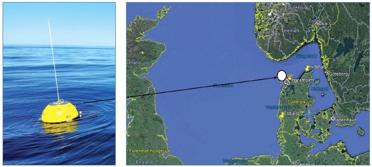
DanWEC Hanstholm North Sea
DanWEC is managing the test site in the North Sea at the westcoast of Denmark by Hanstholm. DanWEC supports WEC developers with application for permits and supply design and wavedata for the site. The water depth is between 15 – 30 meters, and the wave resource about 7 kW/m with max Hs up to 8 meters. The site is marked and equipped with two DataWell buoys measuring wave heights as well as current.
Additional Information
Device Status
Is the test site actively testing or in planning (active)? Or is it permanently closed for business (inactive)?
Active
Energy Resource
- Wave
Duration
April 2009 -
Ongoing
Grid Connectivity
Grid Connected
Waterbody
Roshage Pier, Hanstholm, Denmark
Site Characteristics
Geographic characterization for the test site location:
- Open Ocean: Main body of ocean, not enclosed or partially enclosed by land
- Coastal: Open water near the coast, spanning between land and shelf boundary
- Enclosed Bay: water that is partially surrounded by land, with a mouth open to larger water
- Constricted Channel: A channel where water flows quickly due to narrowing by the land
- River: Water flowing from land towards a larger body of water
Coastal
Country
Denmark
Last Modified
2 June 2025
This Test Site has the following MRE Devices
Filters:
Citation Formats
“DanWEC Hanstholm North Sea.” Marine Energy Projects Database: Test Sites, PRIMRE, United States Department of Energy, https://openei.org/wiki/PRIMRE/Databases/Projects_Database/Test_Sites/DanWEC_Hanstholm_North_Sea. Accessed <day> <monthRoman> <year>.
Marine Energy Projects Database: Test Sites. <year>. "DanWEC Hanstholm North Sea." Accessed <monthRoman> <day>, <year>. https://openei.org/wiki/PRIMRE/Databases/Projects_Database/Test_Sites/DanWEC_Hanstholm_North_Sea.


