Project Manager
PRIMRE/Databases/Projects Database/Projects/Westray South
From Open Energy Information
< PRIMRE | Databases | Projects Database | Projects
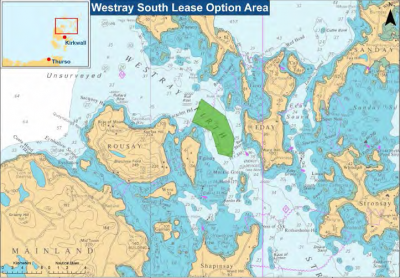
Westray South
The site is located within the Westray Firth approximately 24km to the north of Kirkwall, the nearest sizeable port. The Crown Estate Agreement for Lease area covers approximately 13km2 (excluding grid connection corridor) within which the proposed development would occupy a smaller area; work on identifying this and related stakeholder consultation is ongoing. The project development scope for consenting purposes being progressed encompasses the offshore works (tidal generators, array cabling and export cable to shore) and export cable landfall near the village of Tingwall. Development of the onshore substation to which the project will connect and wider grid infrastructure lies outwith the scope of the project. At present the electricity network on Orkney and beyond is not able to accommodate projects of this scale and options for development of new grid connection infrastructure are being investigated.
Additional Information
Project Status
Is the project actively being planned or is deployed in the water (active)? Or was the project canceled or completed (inactive)?
Active
Project Life Cycle
Project Progress through life cycle:
- Planned: Project has identified a deployment location and is preparing for deployment
- Operational: Project is deployed in the water and is active
- Completed: Project was previously deployed in the water
- Decommissioned: Installation has been fully removed in accordance with regulations
- Canceled: Project was canceled before being deployed in the water
Planned
Operational Start Year
2014
Energy Resource
- Tidal
Project Scale
Array
Max Rated Power Capacity
The maximum amount of electricity that can be produced by project, based on available resources and device nameplate capacity.
200 MW
Grid Connectivity
Grid Connected
Waterbody
Atlantic Ocean
Country
United Kingdom
This Project has the following MRE Devices
Filters:
Last modified: 2023-07-14